Liverpool History News Roundup
Having written about the bigger themes this week, I’ve had to skip past a few other interesting links related to the history of Liverpool. So here they are, just for you:
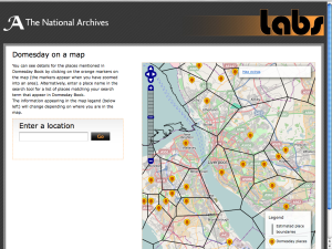
Firstly, as an excitable mapping/interactive/web geek, I was interested in the new Domesday on a Map tool from The National Archives.
This, as the name might suggest, is a map showing all the places mentioned in the Domesday Book. You have to zoom in to see any detail, but once there you get markers indicate the places named in Domesday, with an outline of the rough extent of the manor.
Click on the markers to see the historic name of the place (in 1086) and the page of the Book on which its described.
Director of Technology and Chief Information Officer David Thomas tells us why the map was produced in his blog post on the topic.
Domesday Book predated Liverpool by about 200 years, but a couple of places in the area were very important at the time, and get an entry: West Derby, Woolton, Toxteth and Childwall amongst others.
Whether or not your local history research is in Liverpool, Domesday on a Map is definitely must-see.
Planning permission was submitted to Liverpool City Council last Monday, 4th October, for Liverpool Waters, a plan to develop 150 acres of Merseyside docklands.
The scheme will include the tallest building outside London (possibly to be dubbed the “Shanghai Tower“), and for better or worse will transform Liverpool’s skyline.
Permission has already been granted for Wirral Waters, a similar scheme for the waterfront on the south side of the Mersey.
Planning permission documents have also been submitted for a stretch of Edge Lane including the retail parks and industrial areas.
The scheme will cost £200m and include a new park in addition to ‘leisure and retail units’ (“shops” to you and me).
The Merseyside Civic Society have awarded 8 different projects in four different categories at its relaunched awards scheme.
The categories are best New Build, Green Space, Open Space and Refurbishment. Read the full article on the MCS Awards website.
As two of my regular reads collide, SevenStreets has an article on Colin Wilkinson’s Streets of Liverpool, a site of interest to anyone reading this post I should think.
As well as discussion of how the site started, Colin describes how he came to where he is now, via the Open Eye gallery on the corner of Whitechapel to the Bluecoat Press which he has run since 1992. There are also a couple of classic photos from Colin’s archives.
Well, that’s it for now. Hopefully I’ll have some more Historic Liverpool news sooner or later, as I’m trying to find time for more additions to that site.


