Interactive Historic Maps of Liverpool
Liverpool Landscapes was a blog charting new discoveries, news and developments affecting Liverpool's historic environment. It was regularly updated between 2007 and 2023.
Liverpool Landscapes is now an archive, and all efforts are going into Historic Liverpool.
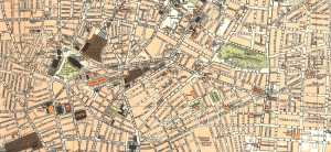
Historic Liverpool has always been primarily about the old maps. Well, now I’m starting to put interactive versions of the ones I own on the site for you to explore.
There are five maps on the Old Maps of Liverpool page now, but I’m hoping to add more as I get them scanned in (which isn’t the cheapest thing ever). Watch this space!
Streets of Historic Liverpool
The maps are all part of an aim to create a resource for local and family historians. Whilst I hope the articles already on the site are useful, I’m hoping to add much more detail, which is why I need your help.
I want to create articles for all the roads in Liverpool. As the best source of information on this is you, the readers and researchers of the world, I’d like to contribute to this effort. As I’ve mentioned before, you can create an account on Historic Liverpool (as a couple of people already have) and get writing. Once logged in, click the Posts entry in the left hand menu, followed by ‘Add New’. Then title your article with the name of the road and put down anything and everything you know about.
This can include personal reminiscences, details of when the road was built, demolished, shortened, widened or anything else. All I ask is that you keep it specific to that road. When you’ve done that, hit the Publish button in the top right and you’re all set!
IF you want to discuss other people’s articles, then you can comment as usual. If someone comments on your article then do respond. I’ll be putting my oar in now and again too.
Street Maps
Now, one other thing of interest for those of you who choose to write about a road: if you visit one of the old maps pages on Historic Liverpool, you will see in the bottom right of these maps a little box marked ‘Permalink’. This is a link to the map at its current location and zoom level, and you can use it to put an interactive map in your article.
Centre the map on the road you are writing about (assuming you’re looking at a map which includes it!) and zoom in to a comfortable level. Now, right click on the Permalink and select something like ‘Copy link address’ or ‘Copy link location’ depending on which browser you are using. This will copy the right link to your computer’s clipboard.
Then, when you are editing your road article, type out the following on its own line:
[iframe src=”link”]
Replace the word link with the URL you copied from the map, leaving the quote marks in place. It should look a bit like this:
[iframe src=”http://maps.historic-liverpool.co.uk/1890plannorth/?zoom=5&lat=-2861&lon=3169.5&layers=B”]
When you hit publish you’ll have a fully-interactive map centred on the road you are writing about! I’ve done one example, for Roscommon Street, to get you going. It’s very short, so do feel free to write as much as you like about your own topic.
If you have any issues with this process, do get in touch, and remember, you can also write about Historic Features as well as roads. Let’s make this the biggest and best record on Liverpool’s historic landscape that there is!
Update: I’ve also started embedding other interactive maps – ones of my own making – in the historic Townships pages. These show you listed buildings, scheduled monuments and other designated historic features. You can add and remove layers, zoom in, and click on each dot or shape for more information.


