New developments at Historic Liverpool
Liverpool Landscapes was a blog charting new discoveries, news and developments affecting Liverpool's historic environment. It was regularly updated between 2007 and 2016.
Liverpool Landscape has now been retired, and most of the less time-dependent articles moved to Historic Liverpool.
In advance of the exciting developments in a couple of weeks’ time (more information anon!) I’ve been polishing the Historic Liverpool website, which has become a little neglected of late.
First up, the homepage has been updated with new buttons to lead you to the main sections of the website. The Old Maps of Liverpool page is the same as it’s been for a while, although with new images to better show what you’ll find on the maps before you click. The most exciting development is that you can now send or save a link to that page which tells the map exactly which position to show. So, for example instead of just going to the Plan of Liverpool – South Sheet (1890) which centres roughly on St. James Cemetery, I can provide a link directly to the Town Hall on the same map.
Great, yes? To do this yourself, simply zoom the map to the position to want to tell all your friends about, then you’ll need the box labelled ‘Permalink’ in the bottom right hand corner of the map. Click that, and the page will reload with a new, longer web address in the address bar of your browser. It’ll look a little like this: http://historic-liverpool.co.uk/plan-of-liverpool-south-sheet-1890?zoom=5&lat=-814&lon=1828.5&layers=B. Simply copy and paste this link into an email, your Facebook page or anywhere else you want to share it! For those who love shortcuts, another option is to right-click on ‘Permalink’ and in the menu which pops up, select ‘Copy Link Location’. Now you can paste it to your heart’s content!
This’ll come in useful when I’m pointing out specific roads or landmarks, so please make the most of it!
Secondly, the Historic Townships page is much as it’s been for a while, giving you access to brief histories of all the townships in Liverpool. These are the familiar suburbs and areas of Liverpool, to help you find out more about where you live, from Fazakerley to Hale. Simply click on an area, and a pop-up bubble gives you the option to read the history, or zoom in to a more detailed map of the historic features found in that area. Again, the Permalink box is there for you to share locations with your friends.
The second link in the pop-up takes you to a zoomed-in version of the Liverpool History Map, which has seen the most changes in the recent developments.
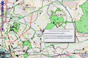
The first button on the home page takes you to the full Liverpool History Map. The first time you load this page, you might have to be a little patient while the data loads (it gets quicker after this), but it’s well worth it! Eventually you’ll see a whole load of grey circles, plus some green, blue and red shapes. The circles are listed buildings on Merseyside, the green areas are Registered Parks and Gardens and the red are Scheduled Monuments.
Click on any of these two find out their name, another detail or two, plus a link to that landmark’s entry on English Heritage’s (EH) National Heritage List for England. Since EH reformed heritage legislation a year or two ago, all the data on this map has a web page associated with it. Explore!
Of the last two buttons on the home page (the square ones), one links to this blog, while the other leads… nowhere, yet. If you haven’t guessed from the image on that button, then hold tight and wait for more information soon! Follow me on Facebook or Twitter to hear all the news first.
Feedback
There is still a lot to do on Historic Liverpool before I consider it ‘finished’, but all the main features are there. Let me know if this all works well on your computer, in your browser of choice. And join in all the conversations in the comments here, on the main site, or via the usual social media rubbish.


